Sunrise over the Grand Canyon is truly spectacular! Silhouettes of thrones and temples highlighted against a rose-orange sky give way as distant canyon walls bloom into color when illuminated by shafts of morning light. As the show brightened into day, we strolled into the El Tovar Dining Room. After enjoying breakfast, my sisters set out to Montezuma Castle on the way to the airport, while my husband and I hiked deeper into the canyon. We wrapped up our last day in the Grand Canyon with a tour of even more dramatic vistas stretching west to Hermit's Rest.
 |
| Just after sunrise at Hopi Point |
 |
| Battleship in the sunrise from Hopi Point |
 |
| Prow of the Battleship seen from Bright Angel Trail |
 |
| Bright Angel Trail |
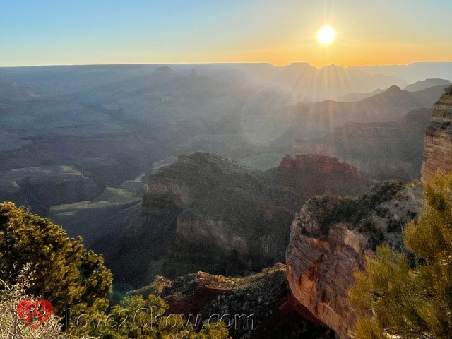
On our last day at the Grand Canyon, we planned to watch the sunrise at 6:05 am, noting that first light was predicted to occur at 5:39 am. Since we were staying so close to the park entrance, we figured we would be fine departing our hotel by 5:15. Although we forgot to factor in time to catch the Red Bus, luck and a bit of early morning running favored us, and we got to Hopi Point in time for a fantastic sunrise! Today was a splendid day for viewing different shades of earthy reds.
Summary and Quick Links
Part 1: Dining and Sunset on the Rim. Sedona, Oak Creek Canyon, Lunch at El Tovar, a toe dip below the rim, Desert View, Navajo Point, Sunset at Lipan Point, Dinner at Plaza Bonita
Part 2: Rafting the Colorado. Rafting from Diamond Creek to Pearce Landing with Hualapai River Runners, Dinner at Diamond Creek Restaurant in Peach Springs
Part 3: The Trail of Time & Grandview Point. Mather Point, Yavapai Museum, Walking Back in Time, Big E Steakhouse, Moran Point, the protection of Ravens, a Grandview Trail Sunset
Part 4: Sunrise, Hiking down & Hermit Road. Hopi Point, Powell Point, an El Tovar breakfast, hiking Bright Angel Trail, Montezuma Castle, The Abyss, hiking Hermit Trail, Pima Point, Mohave Point
Stunning Hopi Point sunrise
The Grand Canyon National Park is open 24/7. When we arrived on Friday morning, there were no attendants on duty at the gatehouse, so we were unable to ask for backcountry maps for trails that descend from Hermits Rest, Grandview Point or Lipan Point. The closest lot to the Bright Angel Lodge was already starting to fill up, no doubt from other sunrise seekers, but we managed to find two spots.
At this point, we realized we did not know exactly where the Red Bus picked up. We saw a bus pull up in front of Bright Angel Lodge with "SUNRISE" on its front. It was for a pre-paid tour that the driver told us cost about $20/person. But after he took us inside to buy the tour, we found the price was nearly twice as high for stops at Maricopa Point and Hopi Point.
After wasting time on this endeavor, we had to run to the stop for the Village Route Transfer west of the Bright Angel complex. We passed several mule deer that gazed quizzically at us, but did not stop to take pictures of them. Thankfully, the Red Bus did not depart until ~5:40. We caught glimpses of the brightening orange sky through the trees.
Hopi Point
When we got off the bus at ~5:53, we were on a path that could go left or right. Left took us to the projecting part of Hopi Point, which is where you want to go. From this area, you can see shadowy ridges and the silhouettes of Wotan's Throne and Vishnu Temple at the horizon.

Looking west, there is a red ridge in the foreground, with the river and variegated beige, red, and grey ridges stretching away into the distance.
 |
| With the brick red Supai-Redwall "Alligator" (best seen from Mohave Point) in the front |
As the orange intensified to the east, the crest of the nearby Battleship is transiently rimmed in a sliver of light.

And the view to the west takes on a soft, muted palette with a pastel sky.

Finally at 6:07 am, the sun peeked over the top of Wotan's throne, taking about 5 minutes to clear it before rising majestically into the sky.

As the first rays of the sun escaped the horizon, the lovely view to the west suddenly became rich in saturated colors. The mauve rocks took on a coppery tone that contrasted sharply with the intense green pines growing on slopes of tan and brown. The most distant Kaibab limestone cliffs radiated gold on the horizon.

As the sky continued to brighten, Horn Creek Rapids is more easily seen .

And as the sun rose higher, crests of successively closer ridge after ridge were crowned in flaming reds and yellows.

Walk to Powell Point
While the outbound Red Bus stops at every stop, there are only a few stops you can take to return to the Village area. Hopi Point is a very short and scenic walk along the Rim Trail east to Powell Point.
The Powell Monument is situated in the middle of the trail on an elevated platform a short walk from the Rim Trail. It is surrounded by a short rock wall that makes a great place to sit for a photo.

Continuing past the monument, there are additional views at the Point itself, including a peek through the trees for a closer view of the Battleship, which is directly beyond and below.

By around 6:45 am, the sun was high enough to throw all of the ridges into knife-like relief.

After 6:30, the shuttle starts running every 10-15 minutes. We caught the shuttle at Powell Point back to the Village and strolled past a group of gentle mules that were saddled up near the Bright Angel Trailhead sign.

Breakfast in the El Tovar Dining Room
In contrast to the afternoon crunch, when it is nearly impossible to get into a dining room without a reservation, there is no problem walking in for a post-sunrise breakfast.
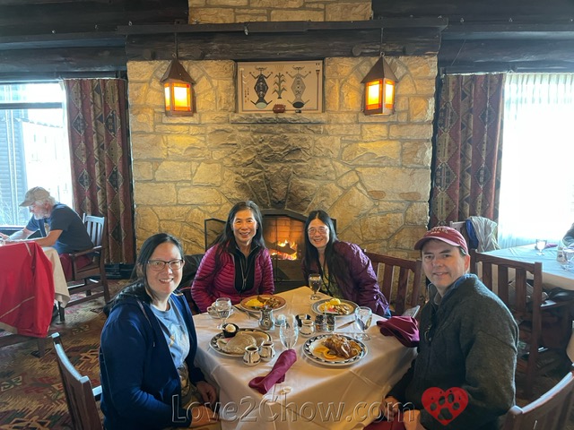
We chose to return to El Tovar for our farewell meal together. All of the rooms in this historic hotel are striking in appearance, and adorned with interesting art. Among the famous people that have dined in here are Presidents T. Roosevelt and Clinton, as well as Sir Paul McCartney.
The El Tovar Dining Room features bright windows and a stone fireplace. According to the website, native stone and Oregon pine were used in its construction. There are murals reflective of the Hopi, Apache, Mojave and Navajo peoples.
Delicious food and considerate service
We were seated near the fireplace and greatly enjoyed our breakfast. Be sure to check the chalkboard on the way in. My husband ordered the pastry of the day, along with the Bananas Foster French Toast, made with brioche in caramel and syrup with sliced bananas and pecans.
 |
| Bananas Foster French Toast; a half serving of the Blackened Rainbow Trout; pastry, possibly a cinnamon bun; Pancake Trio |
My sisters decided to share the Blackened Rainbow Trout. This comes with two eggs, breakfast potatoes and a choice of toast. Just as we experienced in the El Tovar Lounge a few days ago, the server took it upon himself to ask the kitchen to split their order onto two plates.

I was tempted by the Southwestern Avocado Toast and the Huevos Rancheros with beef chorizo and green chili black beans, avocado, but the latter seemed like a huge plate including eggs and potatoes. I enjoyed the El Tovar Pancake Trio, with Native American blue cornmeal and buckwheat pancakes, honey pine nut butter, a red Arizona prickly pear syrup and maple syrup.
Hiking down Bright Angel Trail
On our first day, we hiked only a little way down the Bright Angel Trail, barely getting below the Kaibab Formation that caps the canyon rims. For this longer hike, I hoped to at least get to the 1.5 mile resthouse, and possibly the 3 mile resthouse, but was not sure how the knee I had sprained would feel. I also wanted search more carefully for the Native American petroglyphs that are near the first tunnel.
As we headed down the path at around 8:40 am, we could see that some mules had passed not long before us. Interestingly, by the time we came back up the evidence had been flattened, dried, and probably blown away so there were just some wisps of dried grass.
As I went through the tunnel in the Kaibab Formation, I looked very carefully all along both walls (one guidebooks indicated petroglyphs on the left wall of the tunnel), but there was clearly nothing there.
 |
| The petroglyphs are up overhead on the yellow rocks high above the trail |
So I looked carefully along the cliff walls right after the tunnel, and spotted a red horse and some other figurines high up on the left, sheltered from above by overhanging rock.

As we wound around on the switchbacks, we found ourselves passing the Bright Angel Fault multiple times.

The fault provides the best route to get through the sheer cliff layers, and you can look all the way down the fault line to the cottonwood-rimmed Garden Creek, location of the Indian Garden Campgrounds, and beyond towards Plateau Point.

The trail is generally wide enough for two people to pass easily, with lots of steps.
 |
| Toroweap cliffs |
The white limestone of the Kaibab and Toroweap Formations tower above the trail as you descent, punctuated by pinyon-juniper covered slopes.
 |
| Coconino sandstone towering above the second tunnel |
The 1.5 mile resthouse is situated up some steps from the trail, with dramatic rock pillars behind . Continuing straight in that direction, when the trail takes a sharp left turn, led us to the restrooms --- and a long line.

We had passed a ranger on the way down, who told us we would really enjoy the newly renovated restroom. Alas, it was closed for cleaning, and the cleaning was taking longer than 20 minutes. So a second line had formed behind the building to a private brushy area.
While waiting, I had spotted an interesting view point that jutted out towards Plateau Point, which I wanted to get to. From that view point, we could clearly see that we had descended well below the base of the Battleship.
 |
| Photo by TO. |
Then the canyon drew me down further as I set my sights on the long right-handed angle going through the red Supai layers that we had seen the day before, below the long right-handed white angle in the Toroweap formation above where we had turned around on Day 1.
Apparently there are more petroglyphs at Two Mile Corner, but we did not notice them.

At the corner targeted for my turnaround, I sat on a rock while my husband went on a little further. Of course, the canyon drew me in a little more, and I walked down to a spot where I could see him going pass red ledges.
 |
| Photo by TO. |
From here I could see a set of really steep switchbacks leading to the 3 mile resthouse perched a little ways back from an upcurving point with undoubtedly a fantastic view to the inner canyon.
 |
| The 3 Mile Resthouse roof peeks out near the sharp point curving upwards above the valley. |
Whereas downhill was harder on my knee, uphill felt pretty good at first, particularly as we were walking in the shade. However, once we ascended past the tunnel in the Coconino layer, I had to take more frequent breaks.

Going up gives a different view of the cliffs and fault.

At the base of the Coconino sandstone layer, there is a thin strip of weathered red rock in which I thought I saw little human figurines carved in the pre-Columbian style with the large head to body ratio. Of course, like the many temples and other structures, all of these carvings are due to water, wind and fissures pried slowly apart by ice.

Although hikers going up have the right of way, as it is harder for them to see people coming from above, there are a lot of people that show no trail etiquette. I was almost knocked over one or two times.
Soon we were back to the petroglyphs and Kaibab tunnel, and we knew we were almost back up. We got back at 12:36 pm.

 |
| The Bright Angel fault (green arrows) provides the passage through the vertical cliff layers. Green asterisks mark how far I hiked on Days 1 & 4. Note how the white trail through the four upper layers gives rise to red switchbacks as it traverses the Supai Group (E, We, M, Wa). The Redwall cliff is about halfway down, and consists of pale rock covered with dust from the Supai group — the same dust that now coats my boots. |
Adventures on the Red Bus
Since we had a great parking spot from our pre-dawn arrival, we decided to continue further down the Red Bus line to Hermits Rest, where we could get lunch at the snack bar. It is quite a long bus ride to the end, and we wanted to make sure we got there before the snack bar closed. As mentioned above, there are only 3 stops on the way back from Hermits Rest, so we had to select which of the other stops we were most interested in seeing for the way out.
The Abyss
Our first stop was the Abyss. This viewpoint has the longest sheer vertical drop on the South Rim. You can gaze 3000 ft down. This is one of the few areas of the Grand Canyon in which running water did not play a major role in shaping the topography as there is no fault line nearby.
 |
| The canyon drops vertically past the Redwall to the Tonto Group |
Instead, gravity plays the major role as rock surfaces that fissure off go crashing straight down.
Hermits Rest
By this time, we were getting pretty hungry, so we skipped Monument Point as the bus driver mentioned that most of the rocks that used to stand like monuments had toppled over or washed away.
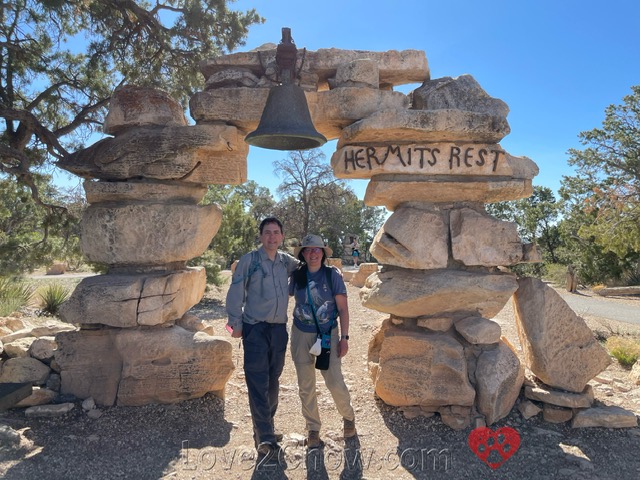 |
Hermits Rest has an interesting bell arch salvaged from a Spanish mission, and good luck is supposed to follow if you have your photo taken under the arch. Said hermit was Louis Boucher, who carved out Hermit Trail and lived near Dripping Springs.
Snack Bar & Historic Gift Shop
On the way to the historic building that houses the snack bar and gift shop, a series of outhouses can be seen on the left, which came in handy after a long bus ride. The Hermits Rest building was one of four designed by Mary Jane Colter, and is supposed to resemble a natural rock formation aside from the stone chimney. The furnishings belonged to Boucher.
 |
| The fireplace inside the historic Hermits Rest gift shop. Photo by TO. |
The menu at the snack bar consisted mostly of junk food, with a choice of three sandwiches: turkey and American cheese, ham and American cheese, or a chicken Caeser wrap. Given our avoidance of flour tortillas unless we know the ingredients (they often contain hydrogenated fats), we decided to share a turkey-American sandwich and a Raven Black & Tan Chocolate chip cookie.

The sandwich consisted of turkey and bread (no sign of cheese) and tasted ok, but was by no means anything to write home about. The cookie was a hybrid of two flavors and quite tasty. I spent some time watching a raven on the path as it picked up what looked like pebbles.
Hiking the Hermit Trail
After lunch we decided to check out the Hermit Trail, although we did not plan to do the entire hike to Dripping Springs or Santa Maria Springs. On the way west to the trailhead, we passed some nice picnic tables with a view of the canyon, which would have been a nicer area to have lunch.

The Hermit Trail was built in 1911 and drops steeply for the first 2.5 miles or so. In many places you can see that it once had paving stones that had fallen into disrepair.

There was a lot of plant life along the trail, which gave it a different appearance from the other trails.

After about a quarter mile, we started to see more expansive views of the canyon. We turned around at about 0.3 miles so that we could continue our bus tour of view points.

Pima Point

Pima Point gave us a great view of an interesting textured plateau with parts of the Tonto Trail.

The signs indicated that this was one of the places where you could hear the roar of Granite Rapids, but unfortunately, we had a several groups of talking people nearby and were unable to hear anything.

Mohave Point
The central feature at Mohave Point is this ridge of textured brick red rock stretching from below the point towards the Colorado River. This structure, named "The Alligator" by Emery Kolb, looks like it is crawling away from the river to which its tail is pointing. Apparently, it is the same red Supai group and Redwall structure west of Hopi Point, which was so beautifully illuminated by the rising sun this morning.

Salt Creek, Granite and Hermit rapids can be seen from Mohave Point.

Departing the Grand Canyon
Montezuma Castle National Monument
While we were hiking on the Bright Angel Trail, my sisters stopped by the Montezuma Castle National Monument on their way back to the Phoenix Airport. According to wikipedia, this is the 3rd National Monument for preserving Native American culture, in this case the Sinagua people who lived here between AD1100 and 1425.
The name of the monument reflects an arrogant misconception that the Aztecs were the only dwelling-building culture. There is an accompanying site in the monument called Montezuma's Well, which is a bit north of the Castle. In reality, these sites were abandoned 40 years before Montezuma, who has nothing to do with these cultures, was even born.
 |
| Photo by RA. |
The 5 story dwelling is carved up high in a limestone cliff and has 20 rooms. Visitors can only view it from below, but there is another site dedicated to Sinagua dwellings east of Flagstaff at Walnut Canyon National Monument.
 |
| Photo by RA. |
The roof was supported by wood from the Arizona sycamore, which is native to the Verde Valley. It is speculated that the arrival of the Yavapai people may have contributed to abandonment of this site, although the Hopi also trace their ancestry to this area.
Flagstaff Airport
We spent one more night in the Grand Hotel. Our dinner was a chicken salad from Wendy's and a burger with fries. We initially tried McDonalds, but the Tuyasan branch said they do not serve salads.
Although we had flown into Phoenix, we departed from the small airport at Flagstaff, which was several hours closer. In the morning, we drove to Flagstaff and did not even think of getting another use of our annual NPS pass at Walnut Canyon. Instead, we sat for a few hours in the tiny airport.
The Flagstaff airport rental car return consists of parking right in front of the terminal, writing down the mileage and gas, and taking the key inside to a shared counter for all the companies. The security guy stopped every luggage that had food or trail mix inside for inspection, irregardless of whether you were TSA Pre-check or not.
There are only two gates. The waiting area has a nice water bottle filler, which came in handy because we got no beverage service on the flight. Be prepared for really, long lines for the two unisex restrooms as departure times approach and the airport fills up.

Links to other Canyon Posts:
Part 1: Dining and Sunset on the Rim. Sedona, Oak Creek Canyon, Lunch at El Tovar, a toe dip below the rim, Desert View, Navajo Point, Sunset at Lipan Point, Dinner at Plaza Bonita
Part 2: Rafting the Colorado. Rafting from Diamond Creek to Pearce Landing with Hualapai River Runners, Dinner at Diamond Creek Restaurant in Peach Springs
Part 3: The Trail of Time & Grandview Point. Mather Point, Yavapai Museum, Walking Back in Time, Big E Steakhouse, Moran Point, the protection of Ravens, a Grandview Trail Sunset
Check out The Grand Canyon of Pennsylvania...
Love2Chow Tips
🐾 As Hermit Road is closed to visitor traffic from March 1-November 30, you will need to catch the Red Bus to get out to Maricopa, Powell, Hopi, Mohave and Pima points. The day before, be sure to identify exactly where the bus will pick up. It is further west than the Bright Angel Lodge area. It starts running 1 hour before sunrise, and buses come every 30 minutes. Hopi Point is the 4th stop and Pima Point is the 8th step.
🍃 Bring a nice reusable water bottle. It is handy for both hiking and short or bumpy airplane rides when the flight attendants have to stay seated.
🐾 Be sure to fill up your water bottles at the trailhead, and read the signs carefully before heading down. There is only a few months when potable water is available at the resthouses, and sometimes the line that brings water from the north canyon breaks down. Thus, it is best to have a water purification plan if you are going further than you can carry water for. I added a Nuun hydration tablet to my water, a citrusy effervescent way to replenish electrolytes lost during exertion.
WHAT IS YOUR FAVORITE HIKE IN ARIZONA?
Please post comments below or photos to Instagram, Facebook or Twitter
Tag @love2chowblog and hashtag it #love2chow
All photos and content © 2022.
All Rights Reserved. Contact admin@love2chow.com for permissions.
All Rights Reserved. Contact admin@love2chow.com for permissions.


0 comments