Grand Canyon 2: Rafting the Colorado River with Hualapai River Runners
By Love2Chow - April 24, 2022
After viewing the dramatic upper canyon from the uppermost layer of the Colorado plateau, one of our most exciting days at the Grand Canyon involved getting up close and personal with some Colorado River rapids! This one day, 55-mile journey hosted by Hualapai River Runners was surely a highlight of our trip. Whitewater thrills, miles and miles of dramatic canyon walls lined by 1.75 billion year old rocks, wildflowers, a waterfall grotto and viewing canyons and peaks of historical and cultural significance. And did I mention the frybread at the Diamond Creek Restaurant afterwards? Sublime perfection.
 |
| Either the Guiness or Bridge Canyon Rapids |
 |
| Vishnu basement rocks with pink Zoraster granite tower above our tiny blue rafts |
 |
| After climbing a ladder going up a waterfall to reach the Travertine Grotto |
While most of our trip consisted of activities selected spontaneously after we had arrived in the National Park, we were happy to have booked a week in advance the One-Day Adventure with the Hualapai River Runners. From a cursory online search, it seemed that this may be the only way to get down to the Colorado River for a day trip in the Grand Canyon (See Tips below). We were lucky that this rafting adventure had just reopened. It was available for only one of the full days our whole group would be together. So I quickly called around to get everyone's approval and put down the nonrefundable fare to reserve it for four people.
We thoroughly enjoyed this experience. Note that you will get thoroughly soaked, unless you stay back on the platform with the cooler through the rapids (you will get wet there, too). So it's best to wear wool or synthetic, quick drying clothing. You will have ample time to dry off during the relaxed cruise past forty some miles of scenic canyon after lunch.
Summary and Quick Links
Part 1: Dining and Sunset on the Rim. Sedona, Oak Creek Canyon, Lunch at El Tovar, a toe dip below the rim, Desert View, Navajo Point, Sunset at Lipan Point, Dinner at Plaza Bonita
Part 2: Rafting the Colorado. Rafting from Diamond Creek to Pearce Landing with Hualapai River Runners, Dinner at Diamond Creek Restaurant in Peach Springs
Part 3: The Trail of Time & Grandview Point. Mather Point, Yavapai Museum, Walking Back in Time, Big E Steakhouse, Moran Point, the protection of Ravens, a Grandview Trail Sunset
Part 4: Sunrise, Hiking down & Hermit Road. Hopi Point, Powell Point, an El Tovar breakfast, hiking Bright Angel Trail, Montezuma Castle, The Abyss, hiking Hermit Trail, Pima Point, Mohave Point
Peach Springs & the Hualapai Reservation
Peach Springs is a small town right off historic Route 66. It is a little over 2 h from Tusayan, so we woke up early with the goal of departing ~5 am. We arrived in Peach Springs at 7:15, and found the gas prices were lower than in Sedona, so we filled up and headed over to the Hualapai Lodge to check in.
The Hualapai (pronounced Wala pie) Nation is one of the few Native American groups whose reservation represents a part of their ancestral lands. They run Grand Canyon West, which includes the Skywalk, a glass walkway over part of a large side canyon near where it enters the Grand Canyon, and their website gives a brief historical introduction.

Bus ride to Diamond Creek
In order to get to the river, we had to take a bumpy 1+ hour, wildly scenic drive down Peach Springs Canyon. Along with way we saw a structure that resembled a space capsule, three wild burros/donkeys, some type of antelope, yellow wildflowers, long-needled pines (but not the Ponderosa pines for which the Hualapai are named, as these require the higher elevation found on the North Rim), lots of cacti, and of course, towering rock formations.

From a distance, we were able to see a triangular peak, which we were steadily winding towards. It turns out this is Diamond Peak, with an elevation of 3512 ft.
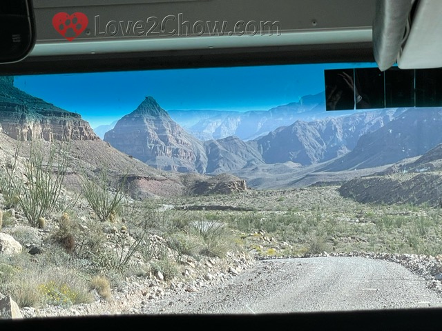
At times, we were driving through a creek bed. Indeed, the beach where we would enter the river is where Diamond Creek joins the Colorado River. It is easy to see why this road may get washed out in the late summer/fall.
When we arrived at the beach, we had the opportunity to use the outhouses, and then we stuffed the bags we wanted to keep dry into a single large, shared dry bag for the raft. We were paired with a family of three, so had a total of 8 people on the raft including our guide Julian.
Rapids & Waterfalls
Very shortly after getting off the beach, we arrived at Diamond Creek rapids. The Grand Canyon has a 10 point rating system for rapids (as opposed to the more standard scale -- A for flat, and I-VI in increasing difficulty). Flat water is a 1 on the Grand Canyon scale, with 10 being roughly equivalent to a Class V rapid. Given that the one-day trip is done on motorized rafts, compared to paddle boats for the 2-day trip, the guides have pretty good control and will ask the group to assess how adventuresome you are feeling.
The rougher and wetter seats are along the sides of the raft towards the front, while those desiring a gentler ride can sit on a wooden platform in the middle of the raft along with the strapped down cooler.
Diamond Creek, Naiad & Travertine Rapids
We entered the river at around mile 225.9. As my husband and I had prior white water experience, I sat in the front along with the father of the smaller family, while my husband sat behind me and the two children sat behind their father. My sisters opted for the platform. Julian indicated that the Diamond Creek Rapid was about a 2 and it looked like a pretty uniform set of small waves as we approached. So I was not expecting to be hit full in the face and drank some river water. In retrospect, it was probably because a 40 horsepower motor drives much harder into the waves than even the most enthusiastic of paddlers.
Interestingly, Diamond Creek Rapid is listed on the river map as a 4 with an 11 ft. drop, whereas the next several rapids are listed as 3s. One of them was called Naiad. The Travertine Rapids features a 7 ft. drop. After running that one, we turned back to the left and landed on a rocky beach at mile 229.
 |
| Travertine Rapids |
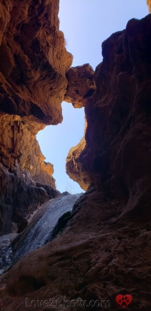
Travertine Falls & Grotto
To get to Travertine Canyon, we had to climb up along some rocks on the shore, to a view of several small cascades. But that was just the prelude to a fantastic scrambling experience.

To the right of the cascades are some pretty smooth slopes of dark schist to which a series of guide ropes, wooden planks and several wood-planked rope ladders ascend.

Once you get to the top of a ladder going up small waterfall, you enter a large grotto.
Towards the back of the grotto, there is a dramatic waterfall, fed by a spring from above. Sunlight streams in through a slit in the cave roof.

After taking lots of photos with this waterfall, you realize you have been standing right under a large round rock that is jammed in the middle of the slit!
Coming back down the schist is a bit more scary than going up.

But the river guides have it all taken care of. It turns out that at the knotted rope, it is quite easy to walk backwards down the slope if you lean back, kind of like rappelling.

Mile 231 and Honeymoon/Killer Fang Rapids
The guide asked if anyone else wanted to try riding in the front, and my sister moved up in front of the two of us, while the daughter in the other family happily crawled back to her seat. After passing the dry waterfall also known as Travertine Falls, we got some closeup views of the chocolate brown Vishnu schist.
 |
| A small clump of wildflowers nestled among river-sculpted Vishnu schist with a fluted appearance. |
The next rapid at mile 231 was a class 5 rapid, with a 12 ft drop and some hydraulics. This one involved what felt like a ceiling of water coming down on our heads. As the lead boat, we were usually first or second through the rapid, which allowed us to turn around and watch the others come through. There were a few where the passengers must have opted for a somewhat slower, gentler ride.
My husband wanted to experience a rapid from the front, so he traded seats with my sister for the mile 232 rapid, which is also known as Honeymoon Rapid according to our guide. He said he would tell us the story behind that name after the class 5-6 rapid.
This was the roughest rapid of the trip! After the wall of water came down on us, I saw my husband's baseball cap floating by towards the back of the raft, and spent much of the rapid reaching forward trying to grab it.
 |
| Honeymoon Rapids |
After we got through the rapid, the water all sloshed forward again, and the father of the other group put out his foot to prevent the cap from going out the front drain. At that point, we realized that the rapid had also knocked off his sunglasses, which were dangling from one ear and held on by the straps he had borrowed from me.
It was pretty dramatic watching the other rafts go through. Link to video.
Two of the rafts got knocked towards these protruding rocks towards our left (their right) -- rocks that give these falls the alternative name Killer Fang falls. But use of the motors allowed them to pivot and steer safely to the left of these.
 |
| Tooth-like rocks (arrows) that the current turns towards, with photographer boat in the eddy |
It turns out that the rapid is named Honeymoon Rapids because a couple, Glen and Bessie Hyde, mysteriously disappeared while running the river in 1928. Their empty scow was found by one of the famous Kolb brothers just downstream with its line stuck to a tree. Nothing was missing from the craft except its passengers.
Guinness, Bridge Canyon, Gneiss Canyon Rapids
After this experience, it was my birthday sister's turn in the front, while my husband moved to the central platform. The next rapid was probably my favorite. Guinness at mile 234 consists of a fairly long train of waves for which you have to first go left and then right.
After the Bridge Canyon rapid at mile 235, my husband mentioned how much he enjoyed the view from the middle of the raft. Because you don't get the ceilings of water crashing over your head, you can actually see each wave and trough as it comes up. So I enjoyed the last rapid on our trip, Gneiss Canyon Rapid, from this view point.
Cruising the Colorado
 |
| View of canyon walls shortly before lunch |
Our course through these rapids follows the same course taken by the 1923 Geologic Survey to identify a potential site to dam the Colorado River. It is quite interesting to read their accounts of the same rapids prior to man's intervention. The famous rapids downstream of Gneiss Canyon, including Separation Rapids, have been drowned by Lake Mead, whose deposits when the lake was high have altered the river bed. Even though Lake Mead has since retreated, these rapids no longer exist.
Our guide pointed out the former site of a proposed dam around mile 238 along with a chunk of canyon wall that had been blasted out with dynamite. Such a dam would have backed up the river for 90+ miles.
 |
| Site of proposed Hualapai dam that was never built |
As we progressed down the canyon, we started to see high up segments of the Redwall Limestone that we had seen the day before from the rim.
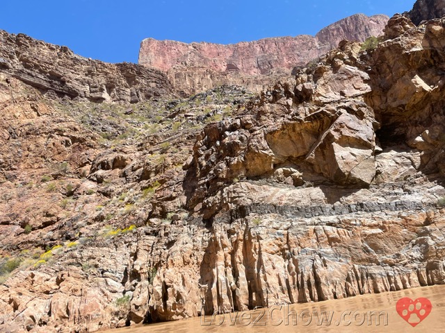 |
| Redwall limestone at top above the basement rocks |
Separation Canyon
There is a tiny historical plaque facing the river and buried in right canyon wall, which I wondered who could ever read, for the site where three men split from the Powell Expedition in 1869 over some disagreement. They left the river and set off by foot towards the Shivwits Plateau and Utah beyond. It is unclear if they were killed by Native Americans as originally thought, or if they were mistaken for federal agents and killed by Mormon settlers who thought they were investigating a militia-led massacre that had occurred earlier.
I saw a heron standing on the rocks at the mouth of this yellow-wildflower strewn canyon. Zoraster pink granite can be seen lacing the dark grey schist on a plateau above the canyon.
A few miles down the river, just after a hairpin turn to the left around mile 243, we pulled onto a wide beach for our lunch. We used our lifejackets as seat cushions and sat on a shelf-like portion of sand, likely marking a higher water level. There were spindly shrubs near the back of the beach, and we tried drying our jackets and hats on these shrubs. There was plenty of privacy going back past the shrubs in either direction for wilderness style bathroom breaks.
Lunch consisted of a ham and cheese sub, assorted chips and carrot sticks with soft drinks and water.
Spencer Canyon
After lunch, we were asked gather on the platform around the cooler to shift our weight towards the back of the raft. This would allow us to cruise at higher speeds without taking on much water through the flat water that characterizes the final 38 miles or so of our journey.

Our river guide Julian mentioned that a man named Charles Spencer, who married a Hualapai woman helped them out in the past, so they honored him by naming a Spencer Canyon after him.
I did some additional research after returning home. According to a book called Making Indian Law, after the disastrous relocation of the Hualapai to La Paz, where many died from malnutrition, Spencer helped the Hualapai stake their claim to Peach Springs with a stone monument. His wife Snyje claimed that he also worked to shield Milkweed and Pine Springs from white encroachment. In any case, it took only 2 years to work out an agreement with the US military culminating with President Chester Arthur signing the executive order in 1883 to create the Hualapai Reservation, but another 20 years to defend it against litigation.
The Three Peaks and Other Rocky Sights
We got to see three peaks that are sacred to the Hualapai people, representing three animals that watch over the canyon.

Across the river is a rock formation called Grandfather, who in turn makes sure the animal guardians do their jobs.
 |
| "Grandfather" |
A bit further along, we saw a huge slab of volcanic igneous rock that had been carried by an ancient flood from far upriver and deposited on a conglomerate hill.
 |
| Volcanic rock carried from miles upstream |
With about 30 miles to go, our motor lost a screw that could be heard rattling around. We had to split up our group, with the smaller half transferring to another raft, while we traveled tied up to the photographer raft until we reached a beach where the dysfunctional craft could be left.
I had hopped easily across the tied together rafts when they asked some of us to move, but then they said they wanted the smaller group. I slipped on the wet metal seat coming back and jammed my knee. Nevertheless, it was quite relaxing laying back on the wood platform watching the clear blue sky and variegated canyon walls drift by.
Skywalk & Pearce Landing
We passed under the Canyon West Skywalk area near mile 266, and was surprised at how tiny that 70-foot protruding loop looks from the river below.
 |
| Closeup (top) of the Skywalk (arrow) as viewed from the river |
About 11-12 miles later, we transitioned out of the canyon walls, arriving at Pearce Landing at mile 280 around 4:15, six hours and 20 minutes after we had launched at Diamond Creek.
Return to Peach Springs & Dinner
As we drove on the bus away from the landing, we passed miles of the now dry portions of lake bed for Lake Mead, which housed lots of low brush and several long horn cattle.
 |
| Dry lake bed with past waterlevels marked by ridges towards the right |
We stopped briefly at an overlook to view the wet part of Lake Mead along with a large specimen of the Joshua Tree. All along Route 25 on our way to Kingman, we saw miles and miles of Joshua Trees -- maybe more than in the national park where vandalism during COVID-19 has destroyed many trees. Turns out this is part of Arizona's Joshua Tree Forest.
 |
| Miles of Joshua trees stretching east from the highway |
There was a stop for purchasing snacks or using the restroom in Kingman, and another optional restroom break that thankfully no one opted for before we returned to Peach Springs. It took over 2 1/2 h to drive back.
Diamond Creek Restaurant
We topped off this adventure with a fabulous, if somewhat slow, meal at the restaurant within the Hualapai Lodge. After taking our orders, our server taught us the proper way to say "Hualapai".
The highlight of this whole meal was undoubtedly the Fry Bread. My sister and I ordered the Hualapai stew, which came with frybread (although had I known she would order the same thing, I might have tried the Pork Green Chili Bowl).
 |
| Freshly made frybread |
The first bite of frybread put me in a state of bliss. I had never tried frybread before and this version offers the thinnest layer of crispy crust overlying pillowy soft goodness. There was a nice flavor reminiscent of funnel cakes, but the texture was completely different and not at all greasy. I could have simply enjoyed a meal of frybread. I am sure that the dessert versions are also sublime.

The stew contained tender chunks of reddish beef with tomatoes, celery, potatoes and carrots. It was refreshing to be able to taste each individual component after the over-salty foods that generally populate restaurants. While I can see some people wanting to add salt or pepper from the shakers on the table, we all thought it was the perfect complement to the frybread.

My other sister ordered the Hualapai Tacos, which was more strongly seasoned, but still not over-salted. The taco beef and beans were served with lettuce, tomato, cheese, salsa and sour cream on more frybread, and my husband enjoyed his burger and fries.

Overall, this rafting trip is a highly recommended experience. Just be aware that you are traveling through a true wilderness area. There are no bathrooms or other amenities and one needs to be able to adapt to a certain level of unpredictability when miles away from the nearest exit from the river.
Love reading about canyon trips?
Check out The Grand Canyon of Pennsylvania...
Grand Canyon Series
Part 1: Dining and Sunset on the Rim. Sedona, Oak Creek Canyon, Lunch at El Tovar, a toe dip below the rim, Desert View, Navajo Point, Sunset at Lipan Point, Dinner at Plaza Bonita
Part 3: The Trail of Time & Grandview Point. Mather Point, Yavapai Museum, Walking Back in Time, Big E Steakhouse, Moran Point, the protection of Ravens, a Grandview Trail Sunset
Part 4: Sunrise, Hiking down & Hermit Road. Hopi Point, Powell Point, an El Tovar breakfast, hiking Bright Angel Trail, Montezuma Castle, The Abyss, hiking Hermit Trail, Pima Point, Mohave Point
Love2Chow Tips
🐾 Hualapai River Runners offers the only day-trip that gets you down onto the Colorado River inside the Grand Canyon, and allows you to experience some rapids. There are other short float trips in smaller canyons. Because of the geography, there is literally no exit from the canyon until you reach the Grand Canyon West area or beyond. Once you get off the rafts, the bus will stop in one or two places for bathroom breaks and snacks on the way back to Peach Springs, depending the needs and desires of people in the group. So be prepared to devote 10-12 hours from check-in to your return to Hualapai Lodge.
🐾 It is best to call ahead to confirm availability, rather than relying solely on web searches, particularly as we emerge from the COVID-19 disruption.The National Park itself was not running at full capacity, with the Visitor's Center closed. (In retrospect, the questions we had and more detailed trail maps were probably available at the Backcountry Office).
🐾 Whereas most Grand Canyon West tickets can be refunded until 24 h before the entry time, the rafting tickets are only refundable up to 30 days prior to the trip (minus a per person service fee).
🐾 If you want to get to the bottom of the Grand Canyon, almost all options require at least one overnight stay as part of the excursion. Take this into consideration before booking a hotel on the rim for a full week, as you may need to split up your booking.
🐾 There might be an option to take a helicopter ride and land briefly somewhere at river level, or to hike down and take a helicopter out, as alluded to in guidebooks that are several years old. However, I found the helicopter websites to be quite confusing; sometimes it was hard to tell where the helicopters were departing from. Many seemed to depart from sites quite far from the National Park itself.
HAVE YOU RAFTED OR HIKED DOWN TO THE COLORADO RIVER?
Please post comments below or photos to Instagram, Facebook or Twitter
Tag @love2chowblog and hashtag it #love2chow
All photos and content © 2022.
All Rights Reserved. Contact admin@love2chow.com for permissions.
All Rights Reserved. Contact admin@love2chow.com for permissions.


0 comments