Grand Canyon: From Rim to River the Easy Way

By Love2Chow - April 21, 2022

We visited the Grand Canyon to celebrate a sister's birthday, and found ourselves captivated by the ever-changing light, color and shadows displayed across the immense canyon walls. The allure of the canyon draws you down to see what is just around the corner, while curious ravens and bold squirrels look on. The canyon is so convoluted that you can only get small glimpses of the mighty Colorado River, and it is necessary to go below the rim to fully appreciate this natural marvel. Yet Rim-to-River treks require extensive pre-planning and excellent physical conditioning. This 4-post series highlights how we maximized our Grand Canyon experience more or less spontaneously – no backpacks or mules required. We dined twice at El Tovar with no reservations, enjoyed spectacular sunsets and sunrises, took several small hikes below the rim, and even got up close and personal with the Colorado River, the easy way.

  
Lipon Point - about 10 min before sunset

Rim Trail near El Tovar

On the Rim with the Battleship formation to the left of my elbow.

After sunset at Lipan Point

Dusk at Lipan Point

April is a fantastic time to visit the Grand Canyon. The snows that can extend into March have abated, and you will not have to worry about icy trails along the cooler rim. At the same time, going in the spring helps avoid the deadly heat of the summer and presumably, the peak of the crowds (although it was plenty crowded in some of the parking lots!). After flying in from different parts of the country, our plan was to meet up at a hotel in Cottonwood and drive out together the following morning to the Grand Hotel in Tusayan, AZ, a community on the doorstep of the South Entrance to the Grand Canyon National Park. 

My husband and I had a fabulous roadside dinner on the way out of Phoenix at Tacos Kissi, a Mexican kitchen (2720 W. Bethany Home Road). As I posted on InstagramTacos Kissi has the best tostada I have ever had, with tender shredded beef beneath mounds of lettuce, tomato, avocado and cheese. And squeeze bottles of green and red sauces. My husband loved his carne asada tacos, too. Not only was the food delicious and inexpensive, but also the artwork on the walls was quite interesting. Each one exhibited the ambiguous or hidden pictures type of optical illusion. 

Shredded beef tostada with consomé dip. Can you see the double images in the artwork? 

Summary and Quick Links

Part 1: Dining and Sunset on the Rim.  Sedona, Oak Creek Canyon, Lunch at El Tovar, a toe dip below the rim, Desert View, Navajo Point, Sunset at Lipan Point, Dinner at Plaza Bonita
                                                                                     
Part 2: Rafting the Colorado.  Rafting from Diamond Creek to Pearce Landing with Hualapai River Runners, Dinner at Diamond Creek Restaurant in Peach Springs
                                                                                     
Part 3: The Trail of Time & Grandview Point.  Mather Point, Yavapai Museum, Walking Back in Time, Big E Steakhouse, Moran Point, the protection of Ravens, a Grandview Trail Sunset 
                                                                                     
Part 4: Sunrise, Hiking down & Hermit Road.  Hopi Point, Powell Point, an El Tovar breakfast, hiking Bright Angel Trail, Montezuma Castle, The Abyss, hiking Hermit Trail, Pima Point, Mohave Point 


On the Way...

From Cottonwood, our route to the South Entrance took us past Sedona, Flagstaff and Williams. Sedona is a destination all to itself, with some striking striped buttes and mesas that we also saw from the air on our last day flying out from Flagstaff. On our way to Sedona, we saw a number of hot air balloons in the air, and as we neared Flagstaff, we could see the snow-capped San Francisco peaks. We drove a segment of Route 66 through Williams, to pick up some snacks and sunscreen from the Safeway with a surprisingly crowded parking lot. Heading north on Route 64, the main road to the park, about 15-25 old fashioned race cars passed us going south. We wondered if there had been an event or gathering in the park.

Sedona Rocks, Buttes and Mesas

We stopped by the tiny Sedona airport in a quest for new batteries for one of the rental car key fobs, but were unsuccessful. On the way out, we enjoyed the view from the Sedona Airport Overlook. The parking near the overlook costs $3/car, which makes sense if you plan to take one of the loop hikes. But in retrospect, we should have simply walked from the airport parking lot for our quick 5-minute look.
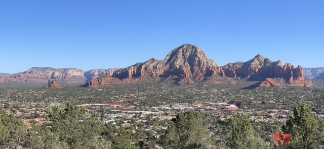
View from Sedona Airport Overlook

Looking past the city into the distance, these striking peaks, buttes and mesas peaked in yellow with red bases rise out from the flat green lowlands. Although there was no interpretive sign to identify the landmarks, the tallest peak is presumably Capital Butte, with Chimney Rock to its left. The vertical red structures on the right represent Coffee Pot Rock with Sugar Loaf in the foreground, presumably part of the red Schnebly Hill Formation that formed from coastal sand dunes originating from sediment eroding the Appalachian Mountains. With the advance and retreat of the ancient Pedregosa Sea, the red rock was covered with white layers of Coconino Sandstone. Read more about the geology of this fascinating area at this link

Oak Creek Overlook & the Native American Artisan Market

Heading north on Route 89A allowed us to stop at the Oak Creek Canyon overlook. The striking rock layers are a bit harder to see than the bald layers closer to Sedona, as the slopes are covered with green pines.  

Oak Creek Canyon

Another reason to stop is to visit the Native American Artisan Market, an open air stretch of tables arrayed with all sorts of goods, from jewelry and ceramics to carved objects. Several of the ceramic pieces resembled wood of some sort. 

Note the bear sitting on the back corner of her table 

But my eye was caught by the beautiful details of an inquisitive bear, carved in hefty ironwood by Henry Esplan, a member of the Navajo nation. 


Grizzlies used to roam Oak Creek Canyon, and the bear symbolizes strength, courage and protection. 


The Grand Canyon Village

It was 11:20 by the time we got to the Grand Canyon National Park sign. 


Even in April, there were lines of cars waiting to get in, and the sign for the passholder line was impossible to see until it was too late. See Tips below for navigating this process. My sister had received suggestions from a friend to head straight to the El Tovar area instead of following the crowds to the main visitor parking lot near Mather Point. Despite this, we had trouble finding parking. 

Two of us got dropped off to try to get a table for lunch at El Tovar, while the other two sought out parking. They eventually got lucky and saw a hidden spot when trying to turn around near the cabins.

El Tovar Lounge: Lunch with a view

The inside of El Tovar lodge reminded us of the Country Bear Jamboree, probably because Disney was inspired by this place. But the mounted elk and bison heads stayed silent and serious here. I overhead the hostess telling a group of 7 that they could try waiting in the bar area to see if some tables would open up, as the Dining Room was full. So I wandered into the lounge area behind the hostess stand and snagged a small table. As we were waiting for news of successful parking, the table right in front of the picture windows opened up.

View from our table

We had lunch with a grand view! We decided to split a few options, and were pleasantly surprised when the server brought the chili split into two bowls and the sandwich cut in half for us. The pulled pork sandwich was fantastic, as the lemon pepper cole slaw added a nice tang. The beef and pork chili was filled with tender, perfectly cooked chunks of meat, but was a bit bland, requiring a couple splashes of hot sauce to add salt, acid and heat. The charcuterie platter had an excellent blend of flavors, textures and colors and was perfect for sharing.

After lunch, we wandered around inside to view the paintings and other artwork. My sister found a painting entitled Quiet at High Noon, which had been painted by Julia Seelos, one of her neighbors.

Trying out the Bright Angel Trail

After lunch, we stepped outside and got our first real view of the canyon, which stretches out in row after row of tangled, steep walled canyons. 

Rim Trail near El Tovar

Reds are the dominant color, interspersed with whites and yellows, greys and dusky green or purple slopes punctuated by flaming orange patches. These are not molten lava patches as seen helicoptering over Haleakala National Park, but according to the helpful labeled photos at Roc Doc Travel, they represent Hakatai Shale eroded en face from the tilted layers of the Grand Canyon supergroup.

As we walked west along the trail, we came to the Bright Angel Trailhead. We filled our water bottles and decided to walk down the trail a little ways to get a sense of dipping below the rim, delaying our tentative plan to complete the 25 mile driving tour of scenic view points stretching to the East Entrance.

Tunnel through Kaibab limestone on the Bright Angel Trail

The trail is pretty wide, allowing for two people to walk past each other comfortably in most areas. As it slopes downward, the first tunnel cuts through the white-tan limestone of the Kaibab Formation, the uppermost layer that forms the rim of the Grand Canyon. 


Some guidebooks indicate Native American petroglyphs inside or just beyond the tunnel, but we did not spot them until we returned for a longer hike (See Post 4). We walked partway into the sloped Toroweap Formation before turning around.

Distant view of Indian Garden campground, a spring-fed oasis on the way to Plateau Point


Driving Tour of the Rim, Part 1.

There are 9 scenic overlooks between the Village and the East Entrance, along Desert View Drive. As the closest, Mather Point, was likely to be the most congested area in the National Park, we decided to start at Desert View Watchtower and work our way back. The Lonely Planet guidebook says to allow 4 hours for this drive. With our brief detour partway down Bright Angel followed by a walk through the Kolb Brothers Exhibit, it was nearly 3:30 by the time we drove past the mule stables on our way to Desert View. Although we planned to watch the sunset at Moran Point, with its landscape made famous by the art of Thomas Moran, we were so captivated by Lipan Point that we lingered there instead.

Desert View

The Desert View Watchtower is a 70 foot tall stone tower designed in 1932 by Mary Colter, who also designed Bright Angel Lodge, Hopi House and the Hermit's Rest.  It turns out she was born in Pittsburgh, PA!

Unfortunately, the tower was closed so we could not climb to the highest viewpoint on the South Rim. Despite this, we enjoyed our first view of the Colorado River as it wound its way towards us from a gap in vertical red cliffs that split the plateau to our right. It was taupe in color, and seemed still and flat from a distance. 


Maybe it was the angle of the sun, but the terrain here was more muted in greys, dull purples and mauve compare to the area by the Village.  

Navajo Point

At 7,461 feet, Navajo Point has the highest natural elevation on the South Rim. We enjoyed views of the Watchtower in the distance. And due to the angle, it was easier to see the Painted Desert out to the east of the Park. 


Again, we had a nice view of the river, and the dusky grey, purple and mauve peaks were capped by erosion-resistant structures that almost looked architectural.  In some of the shaded areas of the canyon, we saw patches of snow that had not melted.


Sunset at Lipan Point

Lipon Point was magnificent. This is a truly expansive viewpoint with plenty of room to spread out. To the right, were rows and rows of complex ridges topped by temples similar to what we observed at Navajo Point. There was more of the river, curving around the Unkar Delta that used to house a Native American (Anasazi) village.

View of Unkar Delta shortly after sunset

It is easy to see the upward slope going from right to left, called a monocline, which is caused by the geological forces that created the uplift that makes the Grand Canyon so deep. 


Red, beige and yellow rock formations stand out in the foreground, while glistening out from the dusk-shadowed ridges to the left is a view of Hance Rapids. This region of the river cuts through the deepest layers of bedrock, the chocolate brown Vishnu Basement rocks, to form Granite Gorge. 


And to the far left are knife-like ridges jutting from a broad plateau awaiting the sunset. Although it was about 2 h to sunset when we arrived, these broad stepped rocks to the left of the railed overlook seemed like the perfect spot to watch the sunset. So we sat together on the rocks and watched the ravens flirting with the canyon walls. Had we known that the Tanner Trailhead was just on the other side of the railed area, we might have taken another dip below the rim. 


My sister Zoom-called our mom and brother, so the whole family was together enjoying the canyon views on her birthday. As the sun descended lower and lower in the west, the distant ridges straight ahead fell into beautiful blue-grey ribbons crowned with golden light. 


The rocks to our right started to flame in reds and oranges, peaking about 5-10 minutes before sunset.

Photo by TO


Tusayan

Tusayan is a small town with a gas station, a general store, a handful of restaurants, and the Grand Hotel. 

The Grand Hotel

The lobby of this hotel is quite striking. It features a stone fireplace and there are mounted animal heads all around. The beds were comfortable and there was ample lighting, space for plugs, a refrigerator, safe and microwave.  


There are nice sidewalks and the hotel is an easy walk to area restaurants. We also noticed a large bank of Tesla car chargers tucked over to the right of the hotel building.

On the downside, the hotel refused to store our luggage before the room was available for check-in, so we had to leave the wine in the hot car during the day. Also, we had hoped to dine in their steakhouse, but it was closed all week due to staffing issues. 


Plaza Bonita

So we set out to a local Mexican restaurant, Plaza Bonita. It was a 20 minute wait, which did not seem too bad, but about 15 minutes into the wait, they said the restaurant had to shut down for some reason. But when we went to return the pager, whatever the situation was had passed...   We enjoyed the chicken enchiladas in mole sauce and the beef taquitos, but found the green chile pork soup to be tasty (especially with the fantastic fresh-made tortillas), but a bit greasy. The seafood molcajete mariscos was impressive in appearance, but a bit too salty to our taste.


Grand Canyon series:
Part 2: Rafting the Colorado.  Rafting from Diamond Creek to Pearce Landing with Hualapai River Runners, Dinner at Diamond Creek Restaurant in Peach Springs
                                                                                     
Part 3: The Trail of Time & Grandview Point.  Mather Point, Yavapai Museum, Walking Back in Time, Big E Steakhouse, Moran Point, the protection of Ravens, a Grandview Trail Sunset 
                                                                                     
Part 4: Sunrise, Hiking down & Hermit Road.  Hopi Point, Powell Point, an El Tovar breakfast, hiking Bright Angel Trail, Montezuma Castle, The Abyss, hiking Hermit Trail, Pima Point, Mohave Point 

Love reading about canyon trips?


Love2Chow Tips

🐾 If you already have your 7 day pass, or an annual pass, stay left as you approach the entrance. Even in April, the wait at the entrance exceeded an hour, and the cars were backed up well beyond where you can see the sign. Another tip is to keep track of not just how long the line at each booth is, but also if there is a lane that is moving faster or slower than the others. We got stuck in a short line that did not move because the attendant was extremely chatty.

🐾 Lodging within the Park needs to be booked well in advance. There was nothing available 3 months before an off-season trip in early April. The real season does not start until May when the North Rim opens. We booked at the Grand Hotel in Tuyasan, which is the closest area outside the park. The purple shuttle runs from the IMAX building in Tuyasan to the Visitor Center Parking area within the Park. This saves on parking stress, but is more expensive as it is $20/person on the shuttle compared to $35 a car. 

🍃 Bring a liter-sized refillable bottle (or two if you plan to do any day hiking), or a CamelBak type water reservoir. There are convenient filling stations near the Bright Angel Trailhead, in the Bright Angel Lodge and in the lower level of El Tovar (and probably others) that are open year round. During the late spring and summer months, additional filling stations are also available. All of the water draws from the fresh spring waters of Roaring Springs, which originates out of the Bright Angel Shale near the North Kaibab Trail.


WHAT ARE YOUR FAVORITE VIEWS OR ACTIVITIES NEAR THE GRAND CANYON?

Please post comments below or photos to Instagram, Facebook or Twitter 

Tag @love2chowblog and hashtag it #love2chow 

All photos and content © 2022. 
All Rights Reserved. Contact admin@love2chow.com for permissions.

  • Share:

You Might Also Like

0 comments