Grand Canyon 3: Walking the Rim Trail, Moran Point and Grandview Sunset
By Love2Chow - May 04, 2022
Following our Rim-to-River introduction to the Grand Canyon, played out over the first two days, we returned for a deeper look at its fascinating geology, natural history, and art-inspiring viewpoints along the South Rim. The Trail of Time allowed us to venture back in time (or further down into the canyon) to touch 1.75 billion year old rocks. After a fantastic steak lunch at the Big E Steakhouse, we resumed our driving tour of scenic viewpoints capped by a beautiful Grandview Trail sunset.
 |
| Trail of Time with the ever-present Raven |
 |
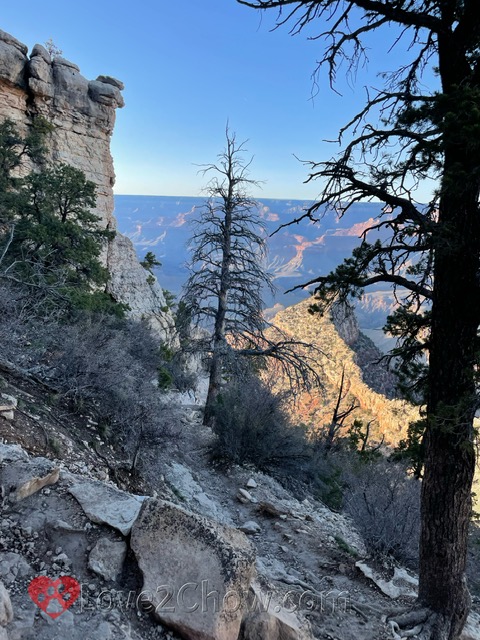
| From upper part of Grandview Trail |
 |
| Peeking at O'Neill Butte from right side of Mather Point |
We enjoyed a leisurely day exploring the South Rim in greater depth. Instead of continuing our driving tour where we left off at Moran Point, we decided to visit the popular Mather Point before it got too crowded. Shortly before 10 am, it was still easy to find parking in the main Visitor's Parking Lot. As we strolled along the Rim Trail, we paid more attention to the plants, animals and birds of the Grand Canyon, as well as taking a closer look at rock layers and key geological features in the National Park.
Summary and Quick Links
Part 1: Dining and Sunset on the Rim. Sedona, Oak Creek Canyon, Lunch at El Tovar, a toe dip below the rim, Desert View, Navajo Point, Sunset at Lipan Point, Dinner at Plaza Bonita
Part 2: Rafting the Colorado. Rafting from Diamond Creek to Pearce Landing with Hualapai River Runners, Dinner at Diamond Creek Restaurant in Peach Springs
Part 3: The Trail of Time & Grandview Point. Mather Point, Yavapai Museum, Walking Back in Time, Big E Steakhouse, Moran Point, the protection of Ravens, a Grandview Trail Sunset
Part 4: Sunrise, Hiking down & Hermit Road. Hopi Point, Powell Point, an El Tovar breakfast, hiking Bright Angel Trail, Montezuma Castle, The Abyss, hiking Hermit Trail, Pima Point, Mohave Point
The Rim Trail
We parked in the Raven 1 lot, near the Mather Point Amphitheater, and walked out to a breathtaking view up the Bright Angel Creek canyon with Buddha Temple on the left and Brahma and Zoroaster Temples on the right. After exploring all the angles and levels of the two railed off viewing areas at Mather Point, we set out on a 2.5 mile hike west to the Bright Angel area, where we caught the orange bus back to our car at Mather Point.
Mather Point
This area includes grand overlooks in three directions, as Mather Point forms a slim fingerlike projection into the canyon. There are steps down to terraced levels with different views. Looking straight out at the tip of Mather Point, the formations to either side of Bright Angel Creek stretch out into the distance.
 |
| Buddha, Brahma & Zoroaster Temples from Mather Point. Photo by TO. |
The tip of the O'Neill Butte cascades down through Redwall limestone, and perhaps a bit of either Temple Butte or Muav limestone, as carved terraces that look almost manmade above the sloped Bright Angel Shale. Interestingly, the Redwall limestone is actually grey in color, but it gets stained red by iron oxide running down from layers above.
 |
| Promontory of O'Neill Butte |
Towards the right side of the point, there are pockmarked, pale Kaibab boulders through which we could see the South Kaibab Trail winding its way down the O'Neill Butte. In the far background are the flat Wotan's Throne and the distinctive Hershey's kiss cookie-shaped Vishnu temple.
 |
| Kaibab limestone craters at Mather Point with Vishnu Temple in background. |
Looking left from the point, we could see the Cheops Pyramid and Isis Temple surrounded by flame colored Hakatai shale peeking through among the tilted purple layers of the Grand Canyon supergroup. And behind Cheops, the Buddha temple can also be seen to the left of the Bright Angel Creek.
 |
| Cheops Pyramid, Isis & Buddha Temples from Rim Trail between Mather Point and Yavapai Point |
As we continued to walk west towards Yavapai Point, we came across a rocky prominence with giant stepped terraces leading down to it. There were several people on it.
 |
| Rocky outcrop viewed from the west, with Wotan's Throne and Vishnu Temple in distance |
My husband and sister decided they wanted to hike down to it. It took a bit of time, but they found a trail on the east side of the rocky outcrop that wound around to the base of the prominence.
 |
| Rocky outcrop viewed from the east. Photo by RA. |
By report, it was a bit vertigo-inducing and we are all glad it was not windy.
Yavapai Point
Yavapai Point was selected as the site of a Geologic Museum because it offers one of the most iconic views of the rock layers forming temples and buttes stretching north from the Colorado River. There are two segments of the river that can be seen, including the suspension bridge on the Kaibab Trail. This bridge, which was built in 1928, required 42 men of the Havasupai Tribe to carry each of the 2,300 pound suspension cables down the South Kaibab Trail.
The once open-air terrace with a commanding view down Bright Angel Canyon is now a glass enclosed terrace. The building also houses many three dimensional exhibits that explain the formation of the canyon. There is a model showing a series of structures extending left from the Bright Angel Creek -- the Cheops Pyramid, Isis Temple and Shiva Temple. There are samples of each structure's hard, resistant caprock to touch, which decrease in age and increase in height from right to left.
 |
| Yavapai Point |
Geology & The Trail of Time
Upon exiting the museum and continuing west, a series of open air exhibits mark the Trail of Time. One long step (about the width of the exhibit sign) represents a million years. After walking two billion years, you get to a section of the trail that focuses on what happened in the last million years,
As you walk back in time, rock samples with one polished cut edge are perched on low pedestals so that you can see and touch these ancient rock layers.
 |
| Up to 1.75 million year old rocks to see and touch on the Trail of Time |
Eventually, we got to a section of trail with a great view of the top half of the Bright Angel Trail. We could see the sharp point in a pale colored part of the trail on the slopes of the Toroweap Formation where we turned around two days ago.
While viewing this part of the canyon, we heard and then saw a helicopter lowering a man to the area by the 1.5 Mile Resthouse. Then it left. A bit later after we had gone further down the trail, it came back and carried off a large dangling load. We think it might have been from cleaning out the restroom.
Trees and Wildlife
Down in Peach Springs Canyon, there were cacti and other desert plants, with more greenery concentrated near the stream bed. Up on the rim, we saw mainly evergreens and wondered if some of them might be the ponderosa pines for which the Hualapai, or "People of the Tall Pines" were named.
Using iNaturalist, however, the trees we saw along the Rim Trail were identified as Colorado pinyon pine or Utah juniper.
 |
| The Battleship framed by juniper and pinyon, with Isis Temple beyond. |
We saw plenty of rock squirrels that seemed unusually bold, but did not see the tufted ears of the Kaibab squirrel. It turns out the Kaibab squirrel favors Ponderosa forests, and Ponderosa pines prefer a higher elevation and are found mainly on the North Rim.
 |
| Female and young elk |
After spending about 4 hours wandering leisurely down the Rim Trail, it was nearly 2 pm and we were hungry. However, we were unable to get a table at the Arizona Steakhouse or El Tovar. So we took the bus back to the car, and headed back to Tuyasan for a late lunch. On our way back out of the park, we saw several grazing elk with shaggy neck and pale rump.
A late lunch at Big E Steakhouse
We really enjoyed our meal at the Big E Steakhouse. It was not very crowded at 3:45 and we were pretty hungry by then. They have these nice open windows up front with screens that could be rolled up or down to filter the harsh rays of the sun. We started with a fantastic spinach salad that had beets, cherry tomatoes, blue cheese and pumpkin seeds.
 |
| Beet salad, prime rib and ribeye. |
I opted for the Canyon Edge Tenderloin Medallions topped with a rosemary peppercorn sauce, while my husband ordered the other choice I was eyeing: the Big E Boneless Ribeye with red wine demi-glace and herb shallot butter. My sisters shared a huge portion of the Kaibab slow roasted prime rib au jus with a creamy horseradish sauce. Everything was delicious.
Driving Tour of the Rim Part 2
Moran Point
It was 5:24 by the time we finally got to Moran Point. This was a favorite site for the landscape painter Thomas Moran. As the light slanted across the sky, it highlighted the highest density of buttes and temples that we had seen as they layered out across the canyon.

Thomas Moran's paintings of Yellowstone played an important role in getting the first National Park established. After painting The Grand Canyon of Yellowstone, he painted The Chasm of Colorado, which depicts a storm over part of the Grand Canyon of Arizona, as he called it. Both these paintings were purchased by Congress.
Grandview Point
We finally arrived at Grandview Point around 5:45 pm, much later than my husband had hoped as he wanted to hike down to Horseshoe Mesa. The shadows were already pretty long, throwing valleys into shadow.

This used to be the site of the Grandview Hotel, run by a former miner Pete Barry, who led mule tours down into the canyon. However, the completion of the Santa Fe Railroad to the village in 1901 put him out of business as no one wanted to take the jarring 12 hour stagecoach to Grandview.

Grandview Trail with the Ravens
My husband and sister set out down the trail, but she quickly turned around where the trail became very narrow next to a large rock pillar. My husband sidled around while facing the pillar. He continued down the trail, promising he would only go down for 20 minutes before turning back to ensure he would be off the trail before it got dark.

Where the trail narrows as it edges around a jutting outcrop
I spent some time trying to figure out which structure was Horseshoe Mesa, then walked down the trail to the corner where I could see that first narrow part of the trail, with the sheer drop off opposite to the rock pillar that jutted out into the trail.
 |
| Where the trail narrows as it edges around a jutting outcrop |
 |
| View from just 1/8 mile down Grandview Trail |
The trail was very steep, with washed out areas. As he walked, he reported seeing a pair of ravens that kind of followed him like they were watching over him.
 |
| Ravens on Grandview Trail. Photo by TO. |
Then it was a matter of waiting anxiously for him to come back up. Down the trail, he had cell service and thought he was keeping us informed of his progress, but up on top, we never got any of these messages.
 |
| Looking back up at where the Grandview Trail started. Photo by TO. |
At one point, we saw a guy with a crimson baseball cap and a blue shirt, but it was a false hope as it was not him. Funnily, he took a photo of that guy as he got back near the top. I was very relieved when he got back.
 |
| Sunset in solitude just a little way down the Grandview Trail. Photo by TO. |
Sunset
We enjoyed another beautiful sunset at Grandview Point, from some terraces along the very upper end of Grandview Trail.
 |
| Sunset from the Grandview Trail |
Links to other Canyon Posts:
Part 1: Dining and Sunset on the Rim. Sedona, Oak Creek Canyon, Lunch at El Tovar, a toe dip below the rim, Desert View, Navajo Point, Sunset at Lipan Point, Dinner at Plaza Bonita
Part 2: Rafting the Colorado. Rafting from Diamond Creek to Pearce Landing with Hualapai River Runners, Dinner at Diamond Creek Restaurant in Peach Springs
Part 4: Sunrise, Hiking down & Hermit Road. Hopi Point, Powell Point, an El Tovar breakfast, hiking Bright Angel Trail, Montezuma Castle, The Abyss, hiking Hermit Trail, Pima Point, Mohave Point
Check out The Grand Canyon of Pennsylvania...
Love2Chow Tips
🍃 Be sure to carry at least a liter of water with you in a reusable container. Until mid-May, the many sources of spring water along the trail are turned off. There are refilling stations inside of Bright Angel Lodge, El Tovar Hotel and near the trailhead for the Bright Angel Trail.
🐾 People fall to their deaths at the Grand Canyon in search of that perfect photo. After we returned home, we found out a woman had fallen to her death from that same rocky outcrop just west of Mather Point. There is also a video showing a woman stumbling after stepping back to better frame a photo she was taking of her mom on a narrow promontory. Be sure to never step without looking in the canyon area.
WHAT IS YOUR FAVORITE CANYON VIEWPOINT?
Please post comments below or photos to Instagram, Facebook or Twitter
Tag @love2chowblog and hashtag it #love2chow
All photos and content © 2022.
All Rights Reserved. Contact admin@love2chow.com for permissions.
All Rights Reserved. Contact admin@love2chow.com for permissions.


0 comments